|
Bamboo World
|
 |
« Reply #45 on: July 21, 2015, 05:23:09 pm » |
|
Is the discussion of doing something with the north leg of the IDL completely off the table because of its recent reconstruction?
I wouldn't say the discussion is completely off the table in the long term. The north leg is a visual barrier, but it can be crossed at Denver Ave, Cheyenne Ave, Boulder Ave, Main St, Boston Ave, the Reverend Dr Martin Luther King Jr Blvd, Detroit Ave, Elgin Ave, Greenwood Ave, and Archer St. The north leg mostly preserved Tulsa's street grid, except for Frankfort Ave and tiny portions of Davenport St and Easton St. I wish the IDL had not been built at all. And I wish the north leg had not been repaired recently. That was a waste of money on a bad design. It would be better if it had been constructed as a depressed highway between Cheyenne/Boulder and Elgin/Greenwood. And it would have been better if a new block of Easton St had been built as designed, connecting Detroit and Elgin. Now, Easton is a dead end at Elgin, and it's a long way around, just to go one block. |
|
|
|
|
 Logged
|
|
|
|
|
carltonplace
|
|
« Reply #46 on: July 22, 2015, 07:02:44 am » |
|
I wish the IDL had not been built at all. And I wish the north leg had not been repaired recently. That was a waste of money on a bad design. It would be better if it had been constructed as a depressed highway between Cheyenne/Boulder and Elgin/Greenwood. And it would have been better if a new block of Easton St had been built as designed, connecting Detroit and Elgin. Now, Easton is a dead end at Elgin, and it's a long way around, just to go one block.
If only we had a time machine...the loss of all of that housing stock and those little parks and the creation of the surface parking in their place is a crime. I guess even with a time machine we could not affect white flight to the suburbs. |
|
|
|
|
Logged
|
|
|
|
|
rdj
|
|
« Reply #47 on: July 22, 2015, 07:47:03 am » |
|
I wouldn't say the discussion is completely off the table in the long term. The north leg is a visual barrier, but it can be crossed at Denver Ave, Cheyenne Ave, Boulder Ave, Main St, Boston Ave, the Reverend Dr Martin Luther King Jr Blvd, Detroit Ave, Elgin Ave, Greenwood Ave, and Archer St.
The north leg mostly preserved Tulsa's street grid, except for Frankfort Ave and tiny portions of Davenport St and Easton St.
I wish the IDL had not been built at all. And I wish the north leg had not been repaired recently. That was a waste of money on a bad design. It would be better if it had been constructed as a depressed highway between Cheyenne/Boulder and Elgin/Greenwood. And it would have been better if a new block of Easton St had been built as designed, connecting Detroit and Elgin. Now, Easton is a dead end at Elgin, and it's a long way around, just to go one block.
It is more than a visual barrier. All of I-244 is a true boundary line for many people. When I moved to Tulsa nearly fifteen years ago I was told by my co-workers and the gal helping me get settled to never drive north of I-244. Thankfully I chose to ignore her advice, otherwise I would have never discovered many great places to eat and the wonderful neighborhood, Reservoir Hill, we call home. The barrier the IDL represents also blocks development of the Brady District north. Combine the physical barrier with the political barrier that is the UCAT/OSU land and it will be very hard pressed for near north Tulsa to ever see any of the energy downtown cross over for real change and development. Assuming the IDL will never have a Gipper-eque, "Tear down this wall" moment it would be great to see those places where the street grid connects to be beautified. For those underpasses to be seen as welcoming entry points for those on the north side and the downtown side. How great would it be to look north up Main St, past Cain's, and see a welcoming entry to a mixed-use development rather than a dark underpass to muddy parking lots. Or, for the Denver access to Brady Heights have a nice retail and multi-family building where the Tulsa County Election Board building sits. |
|
|
|
|
Logged
|
Live Generous. Live Blessed.
|
|
|
|
Bamboo World
|
|
« Reply #48 on: July 22, 2015, 02:43:13 pm » |
|
[The north leg] is more than a visual barrier. All of I-244 is a true boundary line for many people. Yes, it's more than a visual barrier. I don't disagree with your points, rdj. And if there were more buildings constructed close to the north leg, on both sides, it would be less of a visual barrier, because it would be less noticeable. The Elgin underpass has been improved. Some of the others could be spruced up, too. |
|
|
|
|
Logged
|
|
|
|
|
TheArtist
|
|
« Reply #49 on: July 22, 2015, 06:03:03 pm » |
|
I think that our discussion here is still hampered by an auto centric mindset. Which is perfectly understandable considering where we live and our history.
How about this for a change of perspective...
Imagine we are growing another Tulsa from downtown out. The auto centric city is still there, but lets just ignore it and start fresh by regrowing a new city (really a classical, old world style city) based on Transit.
How about transit connecting say downtown to north Tulsa, and to the Pearl, Cherry Street, Brookside, Whittier Square, etc.? Imagine nodes along a transit line heading north having zoning for transit and pedestrian lively development. Essentially begin to regrow the city from the downtown out using a classical model via transit instead of highways. Those nodes become small towns/cities in which the central roads, no, lets call them Streets for there is I think a difference, are used mainly by pedestrians or cyclists. Sure you could get from one area to another via a car using roads and highways, but I think in the core of the city it's time to think of evolving away from that. You will only need a few transit routes in and out of downtown.
The larger road grid and the IDL become unimportant to those living in this new "other city" that will begin to grow, the transit lines and the "block grid" of Streets in and around the nodes is whats then important. The IDL from the viewpoint of someone living in this new city, essentially vanishes from our perspective. We don't use them, we don't need them, they are in no way a barrier to where I want to go, etc. When I am in a big city and looking at a transit map, it doesn't show any roads or highways, it shows the transit routes and stops, and that's all I care about and all that matters. Who knows whats in between the stops? Highways? Rivers? Parks, neighborhoods, pasture? I don't care. What matters is each transit station/node/town center and the pedestrian friendly development/streets/neighborhoods radiating a decent walk/bike out from it.
Lets move on from discussion about Highways and Roads for I fear we will get lost and lose sight of talking about Transit and Streets.
If we had to make a choice between getting rid of the IDL and developing there, or spending money on transit and developing that way. I would spend money on transit lines and calculate the development potential around the TOD nodes. If we could do both, fine. But I think the priority, the time and thought should be to not lose sight of a more important picture which imho would be to get transit going and let the people who use the roads and highways with cars go about their business, and in the meantime begin to create a city with people who use transit, and care more about streets instead of roads, and who don't even see the highways.
|
|
|
|
« Last Edit: July 22, 2015, 06:09:10 pm by TheArtist »
|
Logged
|
"When you only have two pennies left in the world, buy a loaf of bread with one, and a lily with the other."-Chinese proverb. "Arts a staple. Like bread or wine or a warm coat in winter. Those who think it is a luxury have only a fragment of a mind. Mans spirit grows hungry for art in the same way h
|
|
|
|
dbacksfan 2.0
|
|
« Reply #50 on: July 22, 2015, 07:30:37 pm » |
|
Artist brings up a point similar to what I was saying earlier about the cities that had done some form of highway removal, and that is those cities already hadd good public transportation in place. And before the whole high speed light rail discussion happens, there really needs to be a change to the basic system to begin with, which usually means more routes and more buses. The other thing along with that is adding transfer stations throughout the metro area, not bus stops, but places where routes cross, three routes at least. It appears that too many buses run downtown instead of doing grid routes along arterial's and increasing the number of buses to reduce wait times, and it seems like so much of town south o I-44 is under served. I think that's a better place to start and money better spent than removing and reconstructing highway sections.
|
|
|
|
|
Logged
|
|
|
|
|
LandArchPoke
|
|
« Reply #51 on: July 22, 2015, 10:30:03 pm » |
|
Artist brings up a point similar to what I was saying earlier about the cities that had done some form of highway removal, and that is those cities already hadd good public transportation in place. And before the whole high speed light rail discussion happens, there really needs to be a change to the basic system to begin with, which usually means more routes and more buses. The other thing along with that is adding transfer stations throughout the metro area, not bus stops, but places where routes cross, three routes at least. It appears that too many buses run downtown instead of doing grid routes along arterial's and increasing the number of buses to reduce wait times, and it seems like so much of town south o I-44 is under served. I think that's a better place to start and money better spent than removing and reconstructing highway sections.
This is a yes and no. Obviously San Francisco and New York both have excellent transit systems - that helps to absorb some of the impact when you remove a corridor that handles 100,000+ cars per day. The Embarcadero removal/reconstruction did involve them constructing a light rail line along this corridor. However, this light rail corridor did not reach into the suburbs where most of the commuters who used the former freeway came from - so mass transit really did not have much of a play in terms of changing the impact to commuters. Portland when they removed Harbour Drive (waterfront freeway) was in the 1972 - Portland's light-rail system opened in 1986. Milwaukee's project did not incorporate any form of rail transit, and they do not have any rail transit metro wide. Chattanooga's reconstruction of Riverfront Parkway also did not incorporate any form of rail transit, and they do not have any rail transit metro wide. http://www.cnu.org/highwaysHere's some traffic count information from INCOG for reference - I think there's misconceptions on how much traffic actually travels these two sections of the IDL. The intersection of 31st & Harvard handles almost as many cars per day as the South Leg of the IDL @ Denver/Cheyenne. Tell me which costs more to maintain and reconstruct? We are on the verge of spending $40/mile just to repave these two sections. That's enough to pay for a mile of Streetcar. If we don't start getting serious about what infrastructure we need to pay for and don't change our thought philosophy nothing will ever change - I believe it starts with the reconstruction of the IDL. South Leg East Leg East Leg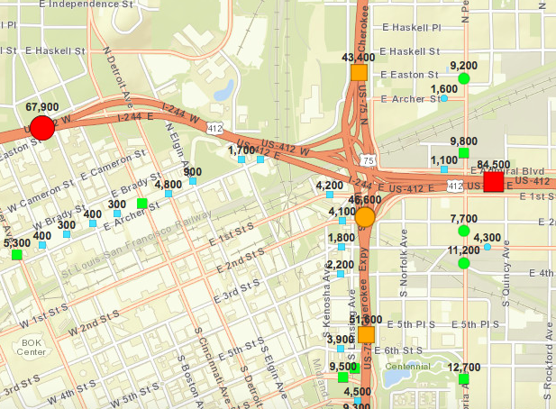 Riverside/71st Riverside/71st Lewis/71st Lewis/71st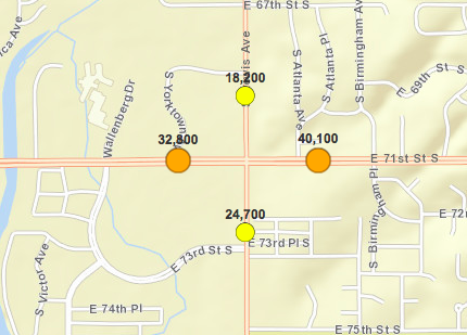 Woodland Hills Woodland Hills Memorial/61st Memorial/61st 169/71st 169/71st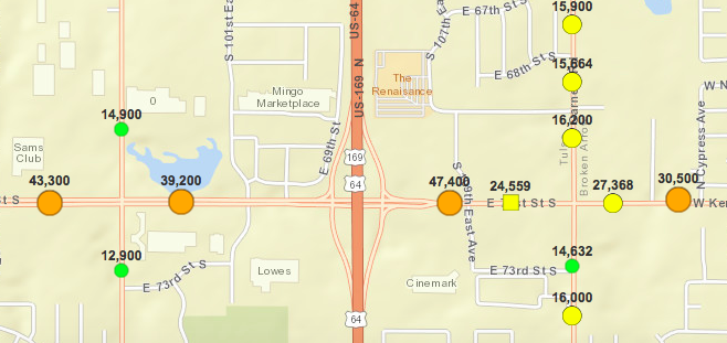 Memorial/101st Memorial/101st Yale/I-44 Yale/I-44 Harvard/31st Harvard/31st |
|
|
|
« Last Edit: July 23, 2015, 09:13:03 am by LandArchPoke »
|
Logged
|
|
|
|
|
LandArchPoke
|
|
« Reply #52 on: July 22, 2015, 10:36:58 pm » |
|
I think that our discussion here is still hampered by an auto centric mindset. Which is perfectly understandable considering where we live and our history.
How about this for a change of perspective...
Imagine we are growing another Tulsa from downtown out. The auto centric city is still there, but lets just ignore it and start fresh by regrowing a new city (really a classical, old world style city) based on Transit.
How about transit connecting say downtown to north Tulsa, and to the Pearl, Cherry Street, Brookside, Whittier Square, etc.? Imagine nodes along a transit line heading north having zoning for transit and pedestrian lively development. Essentially begin to regrow the city from the downtown out using a classical model via transit instead of highways. Those nodes become small towns/cities in which the central roads, no, lets call them Streets for there is I think a difference, are used mainly by pedestrians or cyclists. Sure you could get from one area to another via a car using roads and highways, but I think in the core of the city it's time to think of evolving away from that. You will only need a few transit routes in and out of downtown.
The larger road grid and the IDL become unimportant to those living in this new "other city" that will begin to grow, the transit lines and the "block grid" of Streets in and around the nodes is whats then important. The IDL from the viewpoint of someone living in this new city, essentially vanishes from our perspective. We don't use them, we don't need them, they are in no way a barrier to where I want to go, etc. When I am in a big city and looking at a transit map, it doesn't show any roads or highways, it shows the transit routes and stops, and that's all I care about and all that matters. Who knows whats in between the stops? Highways? Rivers? Parks, neighborhoods, pasture? I don't care. What matters is each transit station/node/town center and the pedestrian friendly development/streets/neighborhoods radiating a decent walk/bike out from it.
Lets move on from discussion about Highways and Roads for I fear we will get lost and lose sight of talking about Transit and Streets.
If we had to make a choice between getting rid of the IDL and developing there, or spending money on transit and developing that way. I would spend money on transit lines and calculate the development potential around the TOD nodes. If we could do both, fine. But I think the priority, the time and thought should be to not lose sight of a more important picture which imho would be to get transit going and let the people who use the roads and highways with cars go about their business, and in the meantime begin to create a city with people who use transit, and care more about streets instead of roads, and who don't even see the highways.
In follow up to what I just posted as well - I'd like to say I really don't want this to be a one or the other. I want this to be the first step in a serious of changes in the way Tulsa invests and develops infrastructure. In my ideal/perfect world - we would negotiate with the State of Oklahoma to create a value capture district around the land the IDL's east and south legs occupy currently. We capture all new sales and property taxes for a 25-year period. Once the reconstruction efforts are paid back we then take the extra revenues to invest in BRT, Streetcar, and Light Rail starter lines. (Odd's are the State would not give up their 4% in sales taxes so it would limit revenue capture potential, but one can dream right?) As you are building the new lines out from Downtown you create further value capture zones around transit stops. The additional tax revenues from infill development then goes into a fund to help extend, maintain, and pay for the operations of the transit system and infrastructure. Essentially creates a waterfall effect that allows you to keep expanding the system. In total - the IDL corridor has the potential to create well over $500 million in property and sales taxes if you develop 1 block per year (~40,000 sq. ft. of retail and 300 residential units per block) for the next 25 years. Imagine if we could create that much new revenue to invest in mass transit over the next 25 years without having to raise taxes. Win - Win in my book. We just can't look at it as a this or that scenario - we have to look at it as a series of strategic investments and events to get Tulsa where Tulsa should be. |
|
|
|
« Last Edit: July 23, 2015, 09:14:32 am by LandArchPoke »
|
Logged
|
|
|
|
|
rdj
|
|
« Reply #53 on: July 23, 2015, 07:57:24 am » |
|
Based on what ODOT did with the I-40 Reconstruction and the way the fought OKC on the new boulevard tells me those negotiations can happen, but it will take a lot of people willing to stand up and hammer this for a long time.
|
|
|
|
|
Logged
|
Live Generous. Live Blessed.
|
|
|
|
LandArchPoke
|
|
« Reply #54 on: July 23, 2015, 09:17:38 am » |
|
Based on what ODOT did with the I-40 Reconstruction and the way the fought OKC on the new boulevard tells me those negotiations can happen, but it will take a lot of people willing to stand up and hammer this for a long time.
That's why I submitted the idea for Vision funding. The proposal and economic returns are more than enough that it could be done without Vision money - but in terms of political pressure being put on ODOT to do what is right for the City of Tulsa and it's citizens there's not a better way to do it then having this as a part of Vision2025 where it's a collaborative community voice saying we choose economic development and responsible infrastructure investments versus throwing another $80 million in the drain. |
|
|
|
|
Logged
|
|
|
|
|
PonderInc
|
|
« Reply #55 on: July 23, 2015, 10:20:58 am » |
|
In follow up to what I just posted as well - I'd like to say I really don't want this to be a one or the other. I want this to be the first step in a serious of changes in the way Tulsa invests and develops infrastructure.
In my ideal/perfect world - we would negotiate with the State of Oklahoma to create a value capture district around the land the IDL's east and south legs occupy currently. We capture all new sales and property taxes for a 25-year period. Once the reconstruction efforts are paid back we then take the extra revenues to invest in BRT, Streetcar, and Light Rail starter lines. (Odd's are the State would not give up their 4% in sales taxes so it would limit revenue capture potential, but one can dream right?)
As you are building the new lines out from Downtown you create further value capture zones around transit stops. The additional tax revenues from infill development then goes into a fund to help extend, maintain, and pay for the operations of the transit system and infrastructure. Essentially creates a waterfall effect that allows you to keep expanding the system.
In total - the IDL corridor has the potential to create well over $500 million in property and sales taxes if you develop 1 block per year (~40,000 sq. ft. of retail and 300 residential units per block) for the next 25 years. Imagine if we could create that much new revenue to invest in mass transit over the next 25 years without having to raise taxes. Win - Win in my book. We just can't look at it as a this or that scenario - we have to look at it as a series of strategic investments and events to get Tulsa where Tulsa should be.
I might be misunderstanding your statement, but we don't have 25 years to wait for transit. Tulsa should have started seriously funding and building transit 25 years ago (including changing our urban design practices to allow transit to function). Since we don't have a time machine, our only option is to start TODAY. |
|
|
|
|
Logged
|
|
|
|
|
rdj
|
|
« Reply #56 on: July 23, 2015, 02:51:10 pm » |
|
In my humble opinion, mass transit is a higher priority than water in the river.
|
|
|
|
|
Logged
|
Live Generous. Live Blessed.
|
|
|
|
LandArchPoke
|
|
« Reply #57 on: July 23, 2015, 02:58:45 pm » |
|
I might be misunderstanding your statement, but we don't have 25 years to wait for transit. Tulsa should have started seriously funding and building transit 25 years ago (including changing our urban design practices to allow transit to function). Since we don't have a time machine, our only option is to start TODAY.
Oh yes - no. I am not saying in 25 years. 25 years is from what I've seen the "limit" to a TIF/BID district. We would form TIF/BID districts on the ODOT Right of Way and capture the value for 25 years, and dedicate all of that value to building transit projects; Light rail, Streetcars, BRT, etc. We would be able to capture in the neighborhood of $500 million - depending on whether the State would allow us to capture their portion of sales taxes and the total sales per sq. ft. the retail would see, anything over $200 per sq. ft. would increase that capture value significantly. This money would be available to spend over the next 25 years without having to ask citizens to raise taxes to pay for transit investments. If you put $500 million into projects, you'd get money back from the fed's as well. Say this project costs the city $63 million that I have said (the $80 million from ODOT is reallocated to offset the additional cost). That leaves "bonding" costs, but you'd have in the neighborhood of $375-400 million you could then funnel into a starter streetcar line. As you plan where the streetcar line goes, you form value capture around transit stations - so when new infill is built, you capture the value you added through the infrastructure. You then take those extra funds to help expand the system one neighborhood at a time. No city in the U.S. has ever taken this strategy. |
|
|
|
« Last Edit: July 23, 2015, 03:01:22 pm by LandArchPoke »
|
Logged
|
|
|
|
|
LandArchPoke
|
|
« Reply #58 on: July 23, 2015, 08:52:39 pm » |
|
I'll add this map below to give everyone an idea in terms of a starter system we could pay for using value capture from new developments built on the IDL east/south leg land. The dots are where stations/stop could potentially be located  https://www.google.com/maps/d/edit?mid=z-k23V4vIJCY.kN_OTzQzWZTA&usp=sharing https://www.google.com/maps/d/edit?mid=z-k23V4vIJCY.kN_OTzQzWZTA&usp=sharingThis is based off a cost of $30 million per mile - this total starter system would cost $309.3 million and extend a total of 10.31 miles. Now imagine how much development potential this could unlock? . |
|
|
|
|
Logged
|
|
|
|
|
Red Arrow
|
|
« Reply #59 on: July 24, 2015, 05:40:35 pm » |
|
I'll add this map below to give everyone an idea in terms of a starter system we could pay for using value capture from new developments built on the IDL east/south leg land. The dots are where stations/stop could potentially be located https://www.google.com/maps/d/edit?mid=z-k23V4vIJCY.kN_OTzQzWZTA&usp=sharingThis is based off a cost of $30 million per mile - this total starter system would cost $309.3 million and extend a total of 10.31 miles. Now imagine how much development potential this could unlock? . You may wish to consider a loop to the TU area. Not every trolley would need to go there. |
|
|
|
|
Logged
|
|
|
|
|


