Ma-Hu was a magnificent place. We - the neighborhood kids to south, west and north of there - would trick or treat 'cause they always gave out good stuff. Rumors told of times before I got to the area when they would give candy plus a silver dollar to every kid willing to walk up that long drive.... Use to play "tag" with the long horn steer....he would always come at you when you came across the fence - looking back, I think it was more curiosity than anything - he didn't really seem 'mean'. There was a small pond on the far southwest corner that was said to have an alligator in residence....
After the decay started (the owner's died) the place was abandoned and again, rumors told of a son/nephew (depending on version) who let it run down. Either way, used to walk around in it exploring in late 60's. Magnificent place - the scale was bigger than any of us had experienced to that time. There were some HUGE beams running through it to support upper floor. The roof rafters looked like beams all on their own.... Basement always had water in it when I would prowl around.
Then they started the "spook house" thing...disgusting thing to do to that building.
Several years before the house burned, there was a large barn at the back, close to 77th east avenue. It caught on fire and it was a very windy day, so the flames were all blowing north, lapping across the roofs of the houses next to it in Johanson Acres (sp?). That was several hundred feet!! Still don't know how one or two of them didn't catch fire - the owners were spraying their roof, but the flames were massive! Scary fire, but all the kids were around watching.
The picture of Memorial was how it was just before we moved to the area - they had JUST paved 2 lanes of asphalt which made it nice. I think they paved it specifically for Oertle's when they built that store there - great store! We shopped at 11th street store a lot, then were thrilled when they built that big box right down the street. 31st was still gravel to the east and all the way to Sheridan to the west. They paved 31st not too long after that.
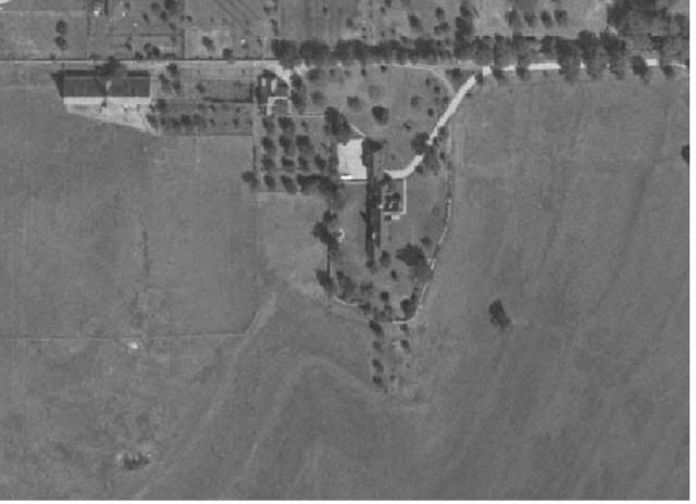
Here is an old aerial photo from 1967 of the MA-HU estate before the fire.
You can this part of Tulsa on this PDF photo:
http://cdm15020.contentdm.oclc.org/utils/getfile/collection/p16063coll3/id/34/filename/35.pdfIt takes a bit to load.
http://www.batesline.com/archives/2014/03/north-of-downtown-tulsa-1967.html


